
Introduction
The goal of the land algorithm is to use the lookup table to determine the conditions that best mimic the MODIS-observed spectral reflectance, and retrieve the associated aerosol properties (including AOD [τ] and fine aerosol weighting [η]). The difficulty lies in making the most appropriate assumptions about both the surface and atmospheric contributions. The mechanics of the land algorithm are shown in the flowchart below.
The land algorithm retrieves aerosol properties in three channels simultaneously (the two visible channels, plus the 2.12 µm channel) and assumes that the 2.12 µm channel contains information about coarse mode aerosol as well as the surface reflectance. The surface reflectance in the visible is a function of the surface reflectance at 2.12 µm, and a function of the scattering angle and the “greenness” of the surface in the mid-IR spectrum (NDVI-like parameter based on 1.24 µm and 2.12 µm channels).
Like the ocean algorithm, the land algorithm is an inversion, but takes only three (nearly) independent observations of spectral reflectance (0.47, 0.65 and 2.1 µm) to retrieve three (nearly) independent pieces of information. These include total t at 0.55 µm (τ 0.55), Fine (model) Weighting at 0.55 µm (η 0.55 ), and the surface reflectance at 2.1 µm (ρs2.12). The land algorithm is based on look-up table (LUT) approach, i.e., radiative transfer calculations are pre-computed for a set of aerosol and surface parameters and compared with the observed radiation field. The algorithm assumes that one fine-dominated aerosol model and one coarse-dominated aerosol model (each may be comprised of multiple lognormal modes) can be combined with proper weightings to represent the ambient aerosol properties over the target. Spectral reflectance from the LUT is compared with MODIS-measured spectral reflectance to find the best match. This best fit is the solution to the inversion.
The collection 6.1 update includes a modification to retrieve aerosol properties over urban areas. Any retrieval area identified as more than 20% urban area based on the MODIS land cover type product (MCD12Q1) uses one of four sets of urban surface reflectance relationships to retrieve aerosol properties. A brief summary can be found on this page. See Gupta et. al. 2016 for a full description.
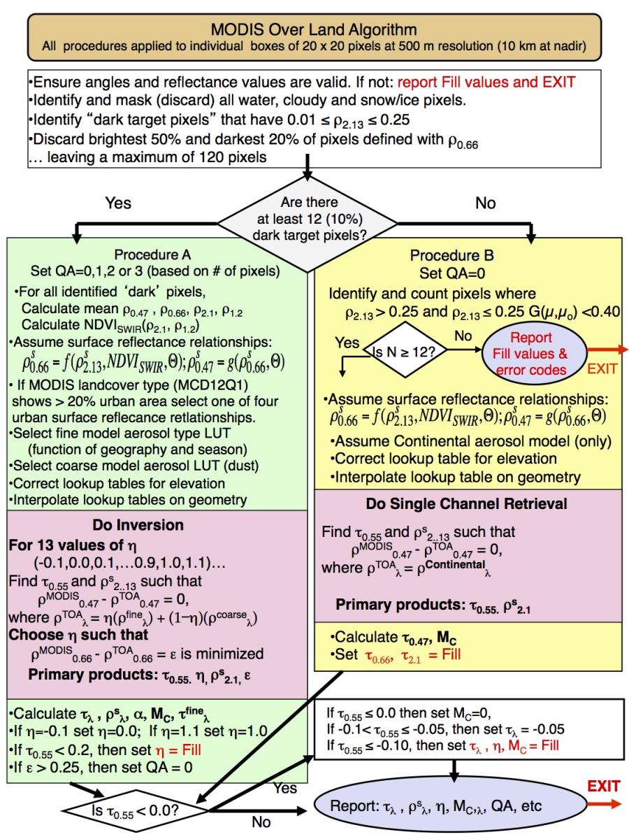
Flowchart for MODIS dark target over land algorithm at 10 Km resolution.