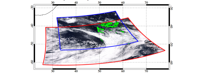
Satellite geophysical products (as opposed to raw data) from polar orbiting instrument are created from individual overpasses of the satellite sensor and are designated as Level 2 products. The Level 2 products are made available in files which are short segments from the full orbit and are referred to as granules. MODIS granules correspond to 5 minute segments and VIIRS granules are 6 minute segments. Geolocation information is contained within the product files so there are no separate data and metadata files as are found in some satellite products. The Terra, Aqua and SUOMI-NPP satellites have a 16 day orbital cycle. Granules from an individual sensor with the same time designation which are 16 days apart should be observing the same geographic location with the same geometry unless an orbital maneuver has been performed in the intervening time period.

Figure 3. Example of a MODIS 5 minute (blue outline) vs VIIRS 6 (red outline) minute granule coverage. Figure is taken from Sayer et. al. 2015
The designation as a 10 km, 6 km or 3 km aerosol product refers to the resolution of the product (not the sensor!) at the center of the satellite swath. These products include retrieval parameters over land and ocean.
| Product Name | Sensor | Product Resolution | Size/Time | File Dimensions |
|---|---|---|---|---|
|
MOD04_L2 |
MODIS-Terra | 10 Km | Granule / 5 minutes | 204 x 135 |
| MYD04_L2 | MODIS-Aqua | 10 Km | Granule / 5 minutes | 204 x 135 |
| MOD04_3K | MODIS-Terra | 3 Km | Granule / 5 minutes | 676 x 451 |
| MYD04_3K | MODIS-Aqua | 3 Km | Granule / 5 minutes | 676 x 451 |
| AERDT_L2_VIIRSSNPP | NPP-VIIRS | 6 Km | Granule / 6 minutes | 404 x 400 |
MODIS 10 km Aerosol HDF file names have the following naming convention:
Terra file: MOD04_L2.AYYYYDDD.HHMM.CCC.YEARDAYHRMNSC.hdf
Aqua file: MYD04_L2.AYYYYDDD.HHMM.CCC.YEARDAYHRMNSC.hdf
YYYY, DDD and HHMM are the four digit year, three digit Julian day, and time of day (hours and minutes) in UTC, CCC is the collection (006 for C6, 061 for C6.1), and YEARDAYHRMNSC represents when the file was processed. 3 Km products will follow the same rules but will start with MOD04_3K or MYD04_3K.
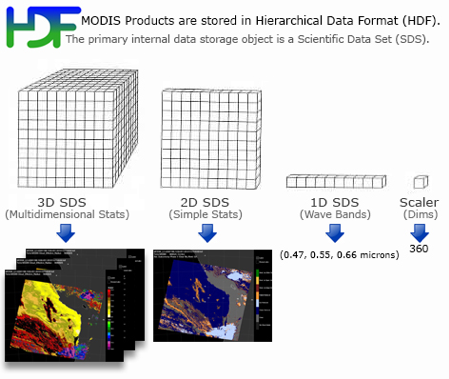
Each retrieval parameter within a product file is termed a Scientific Data Set (SDS). The MODIS 10 km product will include some SDS parameters from the Deep Blue algorithm as well as from the merged dark target-deep blue product. SDS names will indicate if the parameter contains ocean data, land data, or combined ocean and land data. All SDSs are DT unless the name explicitly indicates Deep Blue or a merged product. The 3 km product contains only dark target (no deep blue or merged) SDSs over both land and ocean. VIIRS products do not have a Deep Blue component.
VIIRS files use the following naming conventions which are very similar to MODIS
AERDT_L2_VIIRS_SNPP.AYYYYDDD.HHMM.VVV.YEARDAYHRMNSC.nc
YYYY, DDD and HHMM are the four digit year, three digit Julian day, and time of day (hours and minutes) in UTC, CCC is the collection and YEARDAYHRMNSC represents when the file was processed.
Level 2 Product File Dimensions
Product file dimensions are a function of the granule size, swath width, pixel size and viewing geometry. MODIS 10 Km: The dimensions of the level 2 10 km granule files are 204 (along swath) x 135 (across swath). This represents the number of 10 km pixels in the granule file array. Along swath refers to the path of the satellite and across swath is perpendicular to this direction. In actuality the product is 10 km x 10 km near nadir but the pixels expand in the across swath direction. The further from nadir the greater the expansion due to the "bow tie" effect. This is an effect of the viewing geometry where the pixels grow in size as they approach the end of the swath. At the end of the swath the product may be closer to 40 x 40 km.
MODIS 3 KM: Product granule file dimensions of the level 2 3 km files are 676 (along swath) x 451 (across swath)
VIIRS: The dimensions of the VIIRS 8 km files are 400 (along swath) x 400 (across swath). The effects of the “bow tie” effect have been reduced in VIIRS due to both sensor design and data handling choices. Product dimension at the edge of the swath are approximately 16 x 16 km.
Aerosol Product File Format Basics
HDF formatting as used in MODIS is illustrated below. VIIRS dimensional organization is identical however the file is stored in netCDF-4 format.

All modern computer languages used for analysis will have the capability to read both HDF and netCDF files, if not natively then with a dedicated package.
The VIIRS Dark Target files are saved in netCDF4 format, which is intercompatible with HDF5 (MODIS uses HDF4). Programming functions intended to read HDF5 files will generally work with the VIIRS files, but functions intended for netCDF3 may have unpredictable results, and HDF4 functions will not recognize the file. The most important new feature of the format is the ability to organize datasets into groups, in this case geolocationdata for coordinates and angle information, and geophysical data for datasets from the Dark Target retrieval. In some programming languages, a dataset within a group can be accessed by combining the group and dataset name, for example in IDL:
datasetID = h5d_open(fileID,'/geophysical_data/Optical_Depth_Land_And_Ocean')
Other languages require a command to look up the group ID first, which can then be used in place of the file ID to look up the dataset. See table 4 in the level 2 product contents section for more information.
Official netCDF information, including sample code in several languages: https://www.unidata.ucar.edu/software/netcdf/
